Back Morningside Heights Catalan Morningside Heights German Morningside Heights (Manhattan) Spanish Morningside Heights (Manhattan) Estonian Morningside Heights (Manhattan) Basque مورنینگساید هایتس، منهتن Persian Morningside Heights Finnish Morningside Heights French Morningside Heights, Kota New York ID Morningside Heights Italian
Morningside Heights | |
|---|---|
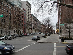
 Residential buildings on West 116th Street opposite Columbia University | |
 Location in New York City | |
| Coordinates: 40°48′35″N 73°57′37″W / 40.80972°N 73.96028°W | |
| Country | United States |
| State | New York |
| City | New York City |
| Borough | Manhattan |
| Community District | Manhattan 9[1] |
| Area | |
| • Total | 0.472 sq mi (1.22 km2) |
| Population (2016)[2] | |
| • Total | 31,884 |
| • Density | 68,000/sq mi (26,000/km2) |
| Ethnicity | |
| • White | 46.0% |
| • Hispanic | 23.5 |
| • Black | 13.6 |
| • Asian | 13.3 |
| • Others | 3.6 |
| Economics | |
| • Median income | $81,890 |
| Time zone | UTC−5 (Eastern) |
| • Summer (DST) | UTC−4 (EDT) |
| ZIP Codes | 10025, 10027 |
| Area code | 212, 332, 646, and 917 |
Morningside Heights is a neighborhood on the West Side of Upper Manhattan in New York City. It is bounded by Morningside Drive to the east, 125th Street to the north, 110th Street to the south, and Riverside Drive to the west. Morningside Heights borders Central Harlem and Morningside Park to the east, Manhattanville to the north, the Manhattan Valley section of the Upper West Side to the south, and Riverside Park to the west. Broadway is the neighborhood's main thoroughfare, running north–south.
Morningside Heights, located on a high plateau between Morningside and Riverside Parks, was hard to access until the late 19th century and was sparsely developed except for the Bloomingdale and Leake and Watts asylums. Morningside Heights and the Upper West Side were considered part of the Bloomingdale District until Morningside Park was finished in the late 19th century. Large-scale development started in the 1890s with academic and cultural institutions. By the 1900s, public transportation construction and the neighborhood's first subway line led to Morningside Heights being developed into a residential neighborhood. Morningside Heights was mostly developed by the 1930s. During the mid-20th century, as the institutions within Morningside Heights expanded, cultural tensions grew between residents who were affiliated with institutions and those who were not. After a period of decline, the neighborhood started to gentrify in the 1980s and 1990s.
A large portion of Morningside Heights is part of the campus of Columbia University, a private Ivy League university. Morningside Heights contains numerous other educational institutions such as Teachers College, Barnard College, the Manhattan School of Music, Bank Street College of Education, Union Theological Seminary, and the Jewish Theological Seminary of America. Additionally, Morningside Heights includes several religious institutions, including the Cathedral of St. John the Divine, Riverside Church, the Church of Notre Dame, Corpus Christi Church, and Interchurch Center. The neighborhood also contains other architectural landmarks, such as St. Luke's Hospital (now Mount Sinai Morningside) and Grant's Tomb.
Morningside Heights is part of Manhattan Community District 9.[1] It is patrolled by the 26th Precinct of the New York City Police Department. Fire services are provided by the New York City Fire Department's Engine Company 47 and Engine Company 37/Ladder Company 40. Politically it is represented by the New York City Council's 7th District.
© MMXXIII Rich X Search. We shall prevail. All rights reserved. Rich X Search